
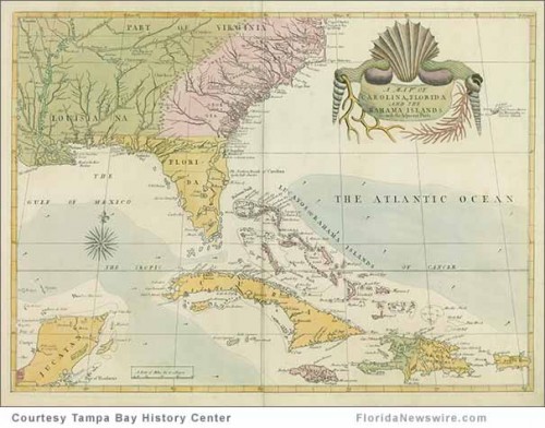
TAMPA, Fla. /Florida Newswire/ — Before the South was “The South,” there was only La Florida. Indeed, nearly 100 years before the English arrived in Virginia, Spanish and French explorers charted a course for “The Land of Flowers.” Marking the quincentenary of Ponce de León’s 1513 landing on Florida’s shores, the Tampa Bay History Center presents Charting the Land of Flowers: 500 Years of Florida Maps, one of the most comprehensive exhibitions of Florida cartography ever assembled.
Opening Sept. 21, 2013, “Charting the Land of Flowers” will bring together 150 maps from museum and library collections around the world, including the Library of Congress, Brown University, and the University of Florida, many of which will be on view to the public for the first time.
The exhibit offers viewers a rare opportunity to see the world as the early European explorers saw it, and to watch the peninsula that would become one of the South’s most populous and diverse states evolve before their eyes. They’ll see that much of the earliest European exploration of North America occurred not in New England, but in Florida and the Southeast, while early railroad maps, atlases, and tourist brochures vibrantly illustrate Florida’s evolution into an agricultural powerhouse and America’s No. 1 tourist destination.
Intricate and colorful ― pink, red, and purple hues abound ― the early maps presented in Charting the Land of Flowers are as much works of art as they are historical documents. Together with manuscript and military maps, satellite images and nautical charts collected for the exhibition, they trace six centuries of exploration, settlement, and growth in the Land of Flowers.
Charting the Land of Flowers: 500 Years of Florida Maps is on exhibit Sept. 21, 2013, through Feb. 16, 2014, at the Tampa Bay History Center. More information at www.Tampabayhistorycenter.org or (813) 228-0097.
Select maps featured in the exhibition:
· 1513 Tabula Terre Nove; Portrays “Old World” at the time of the Ponce de Leon’s Florida landing.
· 1601 Description del Destricto del Avdiencia de la Espanóla; First printed map on which the name “Tampa” appears.
· 1864 “The Capture of Tampa Bay, Florida;” Shows the Union capture of Tampa.
· 1917 American Automobile Association (AAA); Early Florida road map.
· 2009 NASA view of Florida from space taken by astronaut and Clearwater, Fl. resident Nicole Stott.
The Tampa Bay History Center – a Smithsonian Institution Affiliate – includes three floors of permanent and temporary exhibition space focusing on 12,000 years of Florida history. The History Center features a museum store, the Witt Research Center (a branch of the Hillsborough County Public Library System), a map gallery, an event hall and the Columbia Cafe. One of Tampa’s premier cultural venues, the History Center’s cutting-edge interactive exhibits provide a unique educational experience for all ages. www.tampabayhistorycenter.org.


